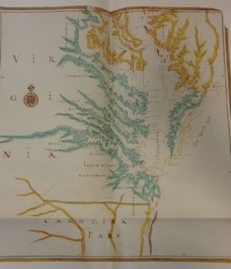
The College of William and Mary was founded before the City of Williamsburg, the former in 1693, the latter in 1699. The original of this map, however, was made at some point before 1683, and was used by the Lords of Trade and Foreign Plantations in London in their administration of the colonies. It shows the area where Williamsburg and the College would be built, at least a decade before they came into being. This was often the only sort of documentation people in London had access to about places they had never seen themselves.
 Rare Book G1805 .B6 1970
The original of this manuscript map is held by the John Carter Brown Library at Brown University, and makes up part of a collection of maps known as “The Blathwayt Atlas.” This was a combination of print and manuscript maps, used by the Lords of Trade, but taken home and kept by William Blathwayt, from whom the collection takes its name. The copy in Special Collections is part of a facsimile that was produced using state-of-the-art technology in the 1970s, with commentary by Jeannette Black. It represents a technology of sharing information and images that is in most respects superseded by modern computers – Brown now makes these maps available in high-resolution scans through their website. However, the facsimile, showing the collection of maps used in running England’s colonies in the Americas, is still interesting as an indication of the technology available to people both in the 1680s and in the 1970s for storing and sharing knowledge.